83 results
Latin handout images
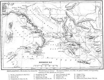
Wanderings of Aeneas Map
A map of Aeneas' wanderings through the Mediterranean from Troy to Italy as described by Vergil / Virgil in his Aeneid.
All images carry the Creative Commons Attribution-NonCommercial-ShareAlike 4.0 International License. That means that, upon the purchase of these images, you are free to share them, i.e. copy and redistribute the material in any medium or format or adapt them, i.e. remix, transform, and build upon them. But this sharing and adapting cannot be applied to any commercial use of t
Subjects:
Grades:
3rd - 12th, Higher Education, Adult Education
Types:

Circumlocute! Support Poster
Based on John Kuhner's list of helpful ways to circumlocute, this resource helps learners stay in the target language by providing topical terms when you don't know the word for the specific item you're talking about. It is great for providing large-picture linguistic support. This works well both as a handout and as a larger-sized wall poster.
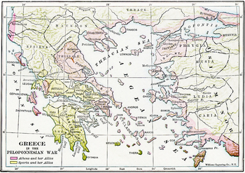
Map of Ancient Greece during the Peloponnesian Wars
A detailed map in color of ancient Greece and the Ionian Peninsula (Turkey) during the Peloponnesian Wars, detailing which cities were allied with Athens and which with Sparta. A high quality .jpg, 600 dpi, and at least 10" x 10" in size, which makes it suitable for printing as well as projecting (unlike many images available on the net).
All images carry the Creative Commons Attribution-NonCommercial-ShareAlike 4.0 International License. That means that, upon the purchase of these images, you
Subjects:
Grades:
3rd - 12th, Higher Education, Adult Education
Types:
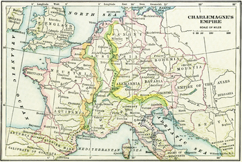
Map of Charlemagne's Empire
A map of Charlemagne's Empire. The first Holy Roman Emperor, crowned by the Pope in 800, Charlemagne united Europe during a mini-Renaissance, spearheaded by his court scholar Einhard. A high quality .jpg, 600 dpi, and at least 10" x 10" in size, which makes it suitable for printing as well as projecting (unlike many images available on the net).
All images carry the Creative Commons Attribution-NonCommercial-ShareAlike 4.0 International License. That means that, upon the purchase of these image
Subjects:
Grades:
3rd - 12th, Higher Education, Adult Education
Types:
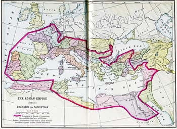
Color Map of the Roman Empire from Augustus to Diocletian
A color map of the Mediterranean with the border of the Roman Empire during both Augustus' and Diocletian's reign is clearly delineated. A high quality .jpg, 600 dpi, and at least 10" x 10" in size, which makes it suitable for printing as well as projecting (unlike many images available on the net).
All images carry the Creative Commons Attribution-NonCommercial-ShareAlike 4.0 International License. That means that, upon the purchase of these images, you are free to share them, i.e. copy and re
Subjects:
Grades:
3rd - 12th, Higher Education, Adult Education
Types:
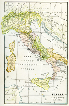
Color Map of Ancient Italy
A color map of Ancient Italy with labels in Latin and Rome labeled prominently. A high quality .jpg, 600 dpi, and at least 10" x 10" in size, which makes it suitable for printing as well as projecting (unlike many images available on the net).
All images carry the Creative Commons Attribution-NonCommercial-ShareAlike 4.0 International License. That means that, upon the purchase of these images, you are free to share them, i.e. copy and redistribute the material in any medium or format or adapt
Subjects:
Grades:
3rd - 12th, Higher Education, Adult Education
Types:
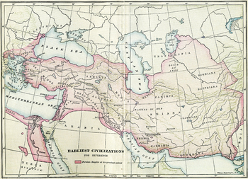
Earliest Civilizations Map
A map of the Near East, showing the earliest civilizations of the west, with the Persian Empire highlighted. Bactria, Assyria, Mesopotamia, and others are shown. A high quality .jpg, 600 dpi, and at least 10" x 10" in size, which makes it suitable for printing as well as projecting (unlike many images available on the net).
All images carry the Creative Commons Attribution-NonCommercial-ShareAlike 4.0 International License. That means that, upon the purchase of these images, you are free to sha
Subjects:
Grades:
3rd - 12th, Higher Education, Adult Education
Types:
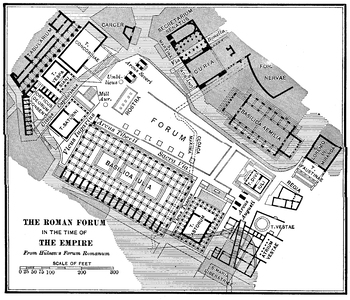
Roman Forum in the Time of the Empire Plan
A detailed plan of the Roman Forum during the Empire, including in it the Basilica Julia, the Rostra, the Basilica Aemilia, the Curia, and the temples at the northwestern corner, among others. A high quality .jpg, 600 dpi, and at least 10" x 10" in size, which makes it suitable for printing as well as projecting (unlike many images available on the net).
All images carry the Creative Commons Attribution-NonCommercial-ShareAlike 4.0 International License. That means that, upon the purchase of th
Subjects:
Grades:
3rd - 12th, Higher Education, Adult Education
Types:
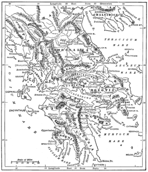
Map of Ancient Greece
A detailed map of ancient Greece. A high quality .jpg, 600 dpi, and at least 10" x 10" in size, which makes it suitable for printing as well as projecting (unlike many images available on the net).
All images carry the Creative Commons Attribution-NonCommercial-ShareAlike 4.0 International License. That means that, upon the purchase of these images, you are free to share them, i.e. copy and redistribute the material in any medium or format or adapt them, i.e. remix, transform, and build upon th
Subjects:
Grades:
3rd - 12th, Higher Education, Adult Education
Types:
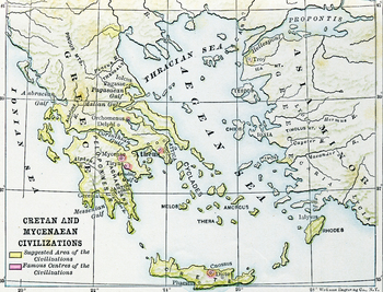
Civilizations of Crete and Mycenae Map
A map of the ancient Aegean, highlighting the Mycenean and Minoan civilizations, centered at Mycenae and Crete, home of Agamemnon, Minos, the Minotaur, Daedalus, etc.. A high quality .jpg, 600 dpi, and at least 10" x 10" in size, which makes it suitable for printing as well as projecting (unlike many images available on the net).
All images carry the Creative Commons Attribution-NonCommercial-ShareAlike 4.0 International License. That means that, upon the purchase of these images, you are free
Subjects:
Grades:
3rd - 12th, Higher Education, Adult Education
Types:
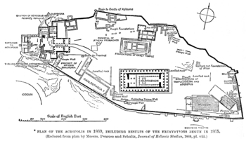
Plan of ancient Athens' Acropolis
A plan of ancient Athens' acropolis, including the Parthenon, the Erectheum, the Propylea, and the museum.
All images carry the Creative Commons Attribution-NonCommercial-ShareAlike 4.0 International License. That means that, upon the purchase of these images, you are free to share them, i.e. copy and redistribute the material in any medium or format or adapt them, i.e. remix, transform, and build upon them. But this sharing and adapting cannot be applied to any commercial use of the images.
F
Subjects:
Grades:
3rd - 12th, Higher Education, Adult Education
Types:
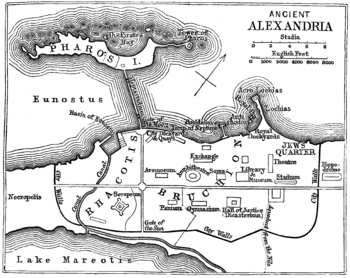
Map / Plan of Ancient Alexandria
A map of the ancient Egyptian city of Alexandria, home to the most famous library in the ancient world. A high quality .jpg, 600 dpi, and at least 10" x 10" in size, which makes it suitable for printing as well as projecting (unlike many images available on the net).
All images carry the Creative Commons Attribution-NonCommercial-ShareAlike 4.0 International License. That means that, upon the purchase of these images, you are free to share them, i.e. copy and redistribute the material in any me
Subjects:
Grades:
3rd - 12th, Higher Education, Adult Education
Types:
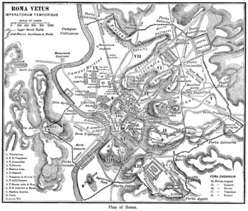
A Keyed Map of Ancient Rome during the Time of the Emperors
A detailed map of Imperial Rome, with 18 buildings identified by key, and the regions of the ancient city identified. A high quality .jpg, 600 dpi, and at least 10" x 10" in size, which makes it suitable for printing as well as projecting (unlike many images available on the net).All images carry the Creative Commons Attribution-NonCommercial-ShareAlike 4.0 International License. That means that, upon the purchase of these images, you are free to share them, i.e. copy and redistribute the materi
Subjects:
Grades:
3rd - 12th, Higher Education, Adult Education
Types:
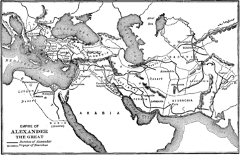
Map of the Empire of Alexander the Great
A map showing the extent of Alexander the Great's empire at its height, from Greece in the West to Persia and India in the West. A high quality .jpg, 600 dpi, and at least 10" x 10" in size, which makes it suitable for printing as well as projecting (unlike many images available on the net).
All images carry the Creative Commons Attribution-NonCommercial-ShareAlike 4.0 International License. That means that, upon the purchase of these images, you are free to share them, i.e. copy and redistribu
Subjects:
Grades:
3rd - 12th, Higher Education, Adult Education
Types:
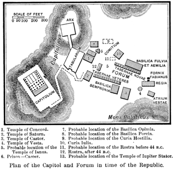
Plan of the Roman Forum and Capitoline during the Republic
A plan of the early Roman Forum as well as the Capitoline hill with the probable locations of various structures identified. A high quality .jpg, 600 dpi, and at least 10" x 10" in size, which makes it suitable for printing as well as projecting (unlike many images available on the net).
All images carry the Creative Commons Attribution-NonCommercial-ShareAlike 4.0 International License. That means that, upon the purchase of these images, you are free to share them, i.e. copy and redistribute t
Subjects:
Grades:
3rd - 12th, Higher Education, Adult Education
Types:
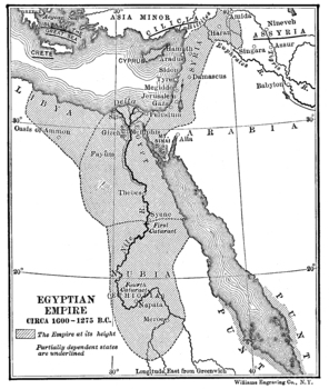
Map of the Egyptian Empire
A map of the Egyptian Empire, c.1000 BCE, focusing on the Nile and the Nile Delta. Location of the pharoahs, pyramids and mummies, Egypt was one of the most dominant empires of the Mediterranean. A high quality .jpg, 600 dpi, and at least 10" x 10" in size, which makes it suitable for printing as well as projecting (unlike many images available on the net).
All images carry the Creative Commons Attribution-NonCommercial-ShareAlike 4.0 International License. That means that, upon the purchase of
Subjects:
Grades:
3rd - 12th, Higher Education, Adult Education
Types:
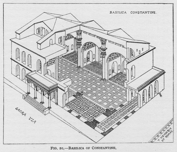
Reconstruction of the Basilica of Constantine
High quality, print-quality, drawing of a cutaway reconstruction of the Basilica of Constantine with the Sacra Via and the Temple of Venus and Rome identified as well.
All images carry the Creative Commons Attribution-NonCommercial-ShareAlike 4.0 International License. That means that, upon the purchase of these images, you are free to share them, i.e. copy and redistribute the material in any medium or format or adapt them, i.e. remix, transform, and build upon them. But this sharing and adapt
Subjects:
Grades:
1st - 12th, Higher Education, Adult Education
Types:
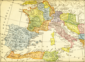
Color Map of the Roman Empire's Western Provinces
A color map of the Western Mediterranean with Spain at its leftmost border and the western coast of Greece at its rightmost, delineating the provinces of the Western Roman Empire. A high quality .jpg, 600 dpi, and at least 10" x 10" in size, which makes it suitable for printing as well as projecting (unlike many images available on the net).
All images carry the Creative Commons Attribution-NonCommercial-ShareAlike 4.0 International License. That means that, upon the purchase of these images, y
Subjects:
Grades:
3rd - 12th, Higher Education, Adult Education
Types:
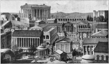
Reconstruction of the Roman Forum
A reconstruction of Rome's forum, looking toward the Capitoline with the Temple of Vesta in the foreground. A high quality .jpg, 600 dpi, and at least 10" x 10" in size, which makes it suitable for printing as well as projecting (unlike many images available on the net).
All images carry the Creative Commons Attribution-NonCommercial-ShareAlike 4.0 International License. That means that, upon the purchase of these images, you are free to share them, i.e. copy and redistribute the material in an
Subjects:
Grades:
3rd - 12th, Higher Education, Adult Education
Types:
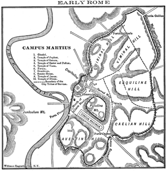
Map of Early Rome
A map of Rome during the Republic with the Forum / Palatine, the Capitoline, and the Campus Martius identified and specific buildings keyed. A high quality .jpg, 600 dpi, and at least 10" x 10" in size, which makes it suitable for printing as well as projecting (unlike many images available on the net).
All images carry the Creative Commons Attribution-NonCommercial-ShareAlike 4.0 International License. That means that, upon the purchase of these images, you are free to share them, i.e. copy an
Subjects:
Grades:
3rd - 12th, Higher Education, Adult Education
Types:
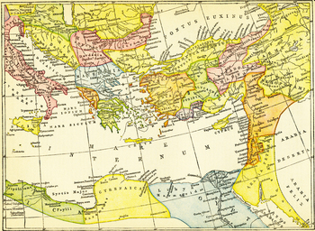
Color Map of the Roman Empire's Eastern Provinces
A color map of the Eastern Provinces of the Roman Empire. Italy and the Black Sea form the northern border of the map and Egypt the southern. A high quality .jpg, 600 dpi, and at least 10" x 10" in size, which makes it suitable for printing as well as projecting (unlike many images available on the net).
All images carry the Creative Commons Attribution-NonCommercial-ShareAlike 4.0 International License. That means that, upon the purchase of these images, you are free to share them, i.e. copy a
Subjects:
Grades:
3rd - 12th, Higher Education, Adult Education
Types:
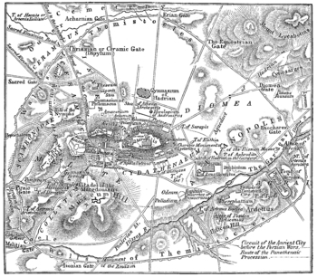
Ancient Athens Map
A detailed map of ancient Athens. A high quality .jpg, 600 dpi, and at least 10" x 10" in size, which makes it suitable for printing as well as projecting (unlike many images available on the net).
All images carry the Creative Commons Attribution-NonCommercial-ShareAlike 4.0 International License. That means that, upon the purchase of these images, you are free to share them, i.e. copy and redistribute the material in any medium or format or adapt them, i.e. remix, transform, and build upon th
Subjects:
Grades:
3rd - 12th, Higher Education, Adult Education
Types:
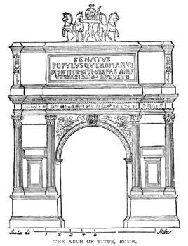
Arch of Titus Outline
A 19th century line drawing of the Arch of Titus with the inscription visible. Located at the south-eastern end of the Roman Forum, it is a single arch constructed in the late 1st c. AD (c.82) to commemorate the sacking of Jerusalem by the emperor Titus.
All images carry the Creative Commons Attribution-NonCommercial-ShareAlike 4.0 International License. That means that, upon the purchase of these images, you are free to share them, i.e. copy and redistribute the material in any medium or forma
Subjects:
Grades:
PreK - 12th, Higher Education, Adult Education
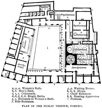
Plan of the Public Baths in Pompeii
The bathhouse for the ancient Romans was a social as well as a hygenic endeavor. The imperial baths of Rome included outdoor spaces, libraries, and workout space as well as the traditional bathe elements. The baths are perhaps most endemic of Roman culture. This is a smaller (i.e. non-imperial) bathhouse from Pompeii with all parts labeled. A high quality .jpg, 600 dpi, and at least 10" x 10" in size, which makes it suitable for printing as well as projecting (unlike many images available on the
Subjects:
Grades:
3rd - 12th, Higher Education, Adult Education
Types:
Showing 1-24 of 83 results


