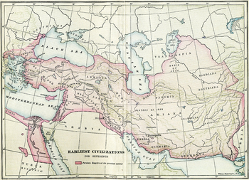
Earliest Civilizations Map
Ed DeHoratius
92 Followers
Grade Levels
3rd - 12th, Higher Education, Adult Education, Homeschool
Subjects
Resource Type
Formats Included
- Jpeg
Pages
1 page
Ed DeHoratius
92 Followers
Description
A map of the Near East, showing the earliest civilizations of the west, with the Persian Empire highlighted. Bactria, Assyria, Mesopotamia, and others are shown. A high quality .jpg, 600 dpi, and at least 10" x 10" in size, which makes it suitable for printing as well as projecting (unlike many images available on the net).
All images carry the Creative Commons Attribution-NonCommercial-ShareAlike 4.0 International License. That means that, upon the purchase of these images, you are free to share them, i.e. copy and redistribute the material in any medium or format or adapt them, i.e. remix, transform, and build upon them. But this sharing and adapting cannot be applied to any commercial use of the images.
For more information about the license, see this link: https://creativecommons.org/licenses/by-nc-sa/4.0/ (and this link, if you dare, for the full, legalese version: https://creativecommons.org/licenses/by-nc-sa/4.0/legalcode).
If you are interested in using the images for commercial purposes, please email me for license pricing at olivewoodphoto@gmail.com.
Total Pages
1 page
Answer Key
N/A
Teaching Duration
N/A
Report this resource to TPT
Reported resources will be reviewed by our team. Report this resource to let us know if this resource violates TPT’s content guidelines.


