
Earthquake Coordinate Lab: Plot current earthquakes using latitude and longitude


- Zip
Also included in
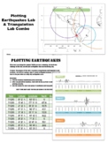 This is a combination pack made up of two of my best labs for use during a plate tectonics/ earthquake unit. Save 15% when you buy these labs together!Lab 1:) Locating Earthquakes:This is a lab to help students explore the triangulation method used to determine earthquake epicenters. I created thisPrice $10.80Original Price $12.00Save $1.20
Description
I am always looking for a latitude/longitude earthquake lab that has NEW data and can never find one... so I made one! Have your students plot real earthquake locations from July 2023. Coordinates are given in degrees, minutes and seconds. Use both, or just have students round to the nearest degree. Minutes and seconds are included in case you would like to print out a larger scale map of a specific location. Use this as a review of latitude and longitude, and as a way to purposefully plot data to explore plate tectonics later! I've included 30 + pages of data, allowing each student to plot real and different data. Please check out the preview file for instructions! HAPPY PLOTTING!
PS. I will be updating this file EVERY SUMMER for you - until I'm no longer a teacher (probably around 2035)... and then I will provide detailed instructions on how to do this yourself!
PPS. A note about the price... I have to manipulate several pieces of data to make it user friendly for students. It takes a fair amount of time to do this! Again, I will update this data EVERY YEAR for you!
PPPS... although the preview file may have data from a preexisting year, this file was updated on 8/14/2023 to reflect the past July's seismic activity.
This work is licensed under a Creative Commons Attribution-NonCommercial-NoDerivatives 4.0 International License.
