
Scavenger Hunt Ancient History Landmarks of the World Digital


- PDF
- Google Apps™
- Internet Activities
- Webquests

Also included in
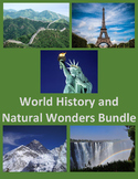 Take a Virtual Tour of the WORLD! Students can see the famous world treasures they hear about. This has Historical and Natural Landmarks. Students can use with PCs or cellphones!Lessons include:- China- Europe- The US- Asia- Ancient History- Medieval History- Renaissance History- Natural Wonders ofPrice $9.99Original Price $18.35Save $8.36
 Students have a Virtual Tour of Ancient History Sites! Students learn where famous landmarks from ancient civilizations are located. See the Pyramids of Giza, the Colosseum and the Great Wall of China! The Lessons are:- Ancient Civilizations- Egyptian History- Roman HistoryCreated by CC FisherOtherPrice $3.95Original Price $6.23Save $2.28
Description
Google Maps is a fun way to learn about the World! Students learn where famous landmarks from ancient civilizations are located. Some of these ancient cultures include: Egyptian, Greek, Roman, Chinese and Peruvian. This also shows the importance of waterways to ancient cultures.
Google Maps has a link to Wikipedia to learn more about each landmark.
Created by CC Fisher
Distance Learning Lessons
Scavenger Hunt Of Ancient Roman History Webquest
Google Maps Scavenger Hunt – Famous City Landmarks of the US
Google Maps Scavenger Hunt – Famous Landmarks of the US
Scavenger Hunt of Medieval Castles and Cathedrals using Google Maps
Google Maps Scavenger Hunt Colonial America
Scavenger Hunt Famous Natural Places of the US using Google Maps
Geography for Distance Learning
Learning the States of the US with Google Maps
Google Maps – The Countries of North America and Central America
Google Maps of the Great Lakes, Major Rivers and Borders of the US
