TPT
Total:
$0.00

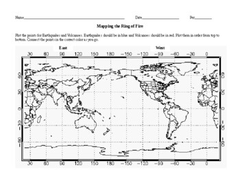
Mapping the Ring of Fire Worksheet with keys for Earthquakes and Volcanoes.

Rated 4.91 out of 5, based on 60 reviews
4.9 (60 ratings)
;
Ian Keith
220 Followers
Grade Levels
5th - 10th, Homeschool
Resource Type
Standards
Formats Included
  • Word Document File
Pages
4 pages
$3.00
$3.00
Share this resource
Report this resource to TPT
Ian Keith
220 Followers

What educators are saying

This was helpful in teaching the students how to read a map, and the relationships between earthquakes and volcano eruptions

Description

This is great worksheet to show students how a seismologist would collect seismic data and plot the coordinates on a map. The coordinates map out the boundaries of the Ring of Fire. You might have to spend a little time teaching the students how to read longitude and latitude but if they have had any experience graphing coordinates in Math then it shouldn't be too difficult. The biggest problem is the East is on the left side of the map and West is on the right. I had to spend a little time with a globe to review the Earth and that helped explain why the map is set up the way it is. This worksheet also shows events that occur along the Mid Atlantic Ridge and the Mediterranean Zone.

Disclaimer: Some plotted points may not show the exact location of some actual events.

Total Pages
4 pages
Answer Key
Included
Teaching Duration
N/A
Report this resource to TPT
Reported resources will be reviewed by our team. Report this resource to let us know if this resource violates TPT’s content guidelines.

Standards

to see state-specific standards (only available in the US).
NGSSMS-ESS2-3
Analyze and interpret data on the distribution of fossils and rocks, continental shapes, and seafloor structures to provide evidence of the past plate motions. Examples of data include similarities of rock and fossil types on different continents, the shapes of the continents (including continental shelves), and the locations of ocean structures (such as ridges, fracture zones, and trenches). Paleomagnetic anomalies in oceanic and continental crust are not assessed.
NGSSMS-ESS2-2
Construct an explanation based on evidence for how geoscience processes have changed Earth’s surface at varying time and spatial scales. Emphasis is on how processes change Earth’s surface at time and spatial scales that can be large (such as slow plate motions or the uplift of large mountain ranges) or small (such as rapid landslides or microscopic geochemical reactions), and how many geoscience processes (such as earthquakes, volcanoes, and meteor impacts) usually behave gradually but are punctuated by catastrophic events. Examples of geoscience processes include surface weathering and deposition by the movements of water, ice, and wind. Emphasis is on geoscience processes that shape local geographic features, where appropriate.

Reviews

Questions & Answers

220 Followers