
Australia Mapping States Territories and Capitals


- Zip
- Easel Activity
What educators are saying
Also included in
 This bundle contains all you need to introduce Australia to your little social studies students. This pack contains maps, celebrations, worksheets and activities, crafts and posters, flags and pendants and some new digital activities to help with distance learning. Lots of activities and craft ideasPrice $30.10Original Price $43.00Save $12.90
Description
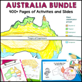
This mapping pack will help your students understand what the Australian states and territories are and where the capitals are located. Students can use the hands-on activities to map Australia's climate, position in the Southern Hemisphere and location worldwide. The companion PowerPoint slides will guide students through each worksheet (with written and cut-and-paste options), the lapbook templates create a fun research project for students, and the fact cards will help guide them in their exploration of each state and territory.
SAVE 30% by buying ALL of my other Australian Social Studies Resources in 1 Bundle!
You can find a Google Slides version here and individual state and territory slides here.
This easy-to-use, best-selling packet includes a PowerPoint and Worksheets on:
- Where is Australia located?
- What countries are near Australia?
- How close is Australia to the equator?
- Which hemisphere is Australia in?
- What is the climate in Australia?
- What are the States and Territories of Australia?
- Where are the capital cities of Australia?
- What is the flag of Australia?
- What are the other flags of Australia?
- Fact Cards:
- Queensland
- New South Wales
- Victoria
- South Australia
- Tasmania
- Australian Capital Territory
- Western Australia
- Northern Territory
- Research lapbook templates
- Australia puzzle pieces
*********************************************************************
ALIGNED TO THE AUSTRALIAN CURRICULUM.
Year 2 HASS Geography:
- The way the world is represented in geographic divisions and the location of Australia in relation to these divisions (ACHASSK047)
- The representation of Australia as states and territories and as Countries/Places of Aboriginal and Torres Strait Islander Peoples; and major places in Australia, both natural and human (ACHASSK066)
- The main climate types of the world and the similarities and differences between the climates of different places (ACHASSK068)
*********************************************************************
☀☀☀☀STAY CONNECTED TO TECH TEACHER PTO3☀☀☀☀
❤️ Follow Me to find out when new products are added ❤️
*********************************************************************
Related Products
• Australia Geography Maps Activities
• Climate Zones Australia Maps Vocabulary Cards and Posters
• Climate Zones Maps Vocabulary Cards and Posters
• Geography Bundle Maps and Activities
• Map Making Geography Prepositional Whole Class Activity
• Map the Bedroom Geography Prepositional Map Making
• Map the Classroom Geography Prepositional Map Making
• Map the Playground Geography Prepositional Map Making
• My Book About Maps - an introduction to mapping
*********************************************************************
Customer Tips:
How to get TPT credit to use on future purchases:
• Please go to your My Purchases page (you may need to login). Beside each purchase you'll see a Provide Feedback button. Simply click it and you will be taken to a page where you can give a quick rating and leave a short comment for the product. Each time you give feedback, TPT gives you feedback credits that you use to lower the cost of your future purchases. I value your feedback greatly as it helps me determine which products are most valuable for your classroom so I can create more for you. ☺
Be the first to know about my new discounts, freebies and product launches:
• Look for the green star next to my store logo and click it to become a follower. Voila! You will now receive email updates about this store. ☺
***************************************************************
