
Ancient China Geography Reading Comprehension Passages and Map Activity


- Zip
What educators are saying
Also included in
 Learn about Ancient China Geography and Agriculture, including the rise of Chinese civilization along the Yellow and Yangtze Rivers and the dramatic differences between Inner and Outer China. Replace or Supplement your existing Textbook!Files are provided in PDF and PPT formats.Convert PPT files intPrice $14.20Original Price $17.75Save $3.55
Description
Learn about Ancient China Geography and Agriculture. Discover how the Yellow and Yangtze Rivers influenced settlement in Ancient China. Tour Inner and Outer China's varied topography. Explore the relationship between China's major agricultural products and its geography and climate. So much great material!
All files are provided in PDF and PPT formats. Convert PPT files to Google Slides for upload to your Google Classroom share site with restricted student-only, password-protected access.
Click the PREVIEW button above to see everything that's included.
WHAT'S INCLUDED?
5 READING COMPREHENSION PASSAGES to print or upload to your student-only, password-protected classroom share site.
- Where in the World - Examine maps to locate China and learn about its geography and climate.
- In the Beginning - Learn about China's initial settlement.
- The Middle Kingdom - Inner and Outer China - Tour China's major regions.
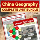
- The Yellow and Yangtze Rivers – Discover the impact of the Yellow and Yangtze Rivers on the development of China. Learn about the modern impact of the Three Gorges Dam.
- What’s for Dinner? – Discover how agriculture in Ancient China relates to its geography and climate.
DIFFERENTIATED COMPREHENSION CHECKS in full-sentence and graphic organizer formats with further differentiation options available for vocabulary. BW and Full-color Versions provided. Full Answer Keys included.
3 MAP ACTIVITIES
- Middle Kingdom - Label major features on a map of China and answer comprehension questions based on the map.
- Absolute and Relative Location - Learn and Practice Absolute and Relative Location skills with a map of China.
- Compare and Interpret Maps – Analyze maps to discover relationships between elevation, precipitation, and temperature.
93 PRESENTATION SLIDES for visual support of all vocabulary and maps along with key photos from readings.
ESSENTIAL QUESTION WRITING PROMPTS with full answer keys
3 BONUS PAGES: (1) Plan a Chinese Food Tasting; (2) Plan a Chinese Food Field Trip; (3) Links to high quality curated video clips about Chinese Geography and Agriculture.
Use this COMPLETE RESOURCE to replace or supplement your existing text. Perfect for Stations and Interactive Notebooks.
Check out my PREVIEW for a detailed look at all that's included.
RELATED RESOURCES:
Save $$$ when you purchase the Ancient China Geography and Agriculture BUNDLE:
- Asia Map Activity – Locate China in the world and learn the countries and selected capitals of Asia
- Chinese Farming Inventions – Infographics show Chinese Agriculture Innovations and Inventions
- Vocabulary Activities – 5 FUN student favorite activities to activate prior knowledge at the beginning of the unit, build and reinforce during the unit, or review at the end of the unit
Provide background on how Precipitation Patterns affect the Geography and Agriculture of an area.
- Water Cycle - Learn or Review each step of the Water Cycle and Threats to the Water Cycle
- Hadley Wind Cells - Learn how Hadley Wind Cells create the World's Rainforests and Deserts
- Rain Shadows- Learn how the Water Cycle and Mountains create the Rain Shadow Effect
- Monsoons - COMING SOON - Apply knowledge of the Hadley Cell, ITCZ, and land/sea wind currents to learn about the tropical locations of Monsoons.
Complete Geography and Agriculture Units for other Ancient Cultures:
Check out this Cross-Curricular STEAM Math resource in my MIDDLE GRADES MATH TPT Store!
- China Climate Data 6th Grade Stats and Probability Cross-Curricular BUNDLE Activity - Full-Page, Step-by-Step Instructional Notes and Activities teach ALL 6th Grade Statistics and Probability standards. Then apply those skills to Chinese Climate Data.
Click HERE to FOLLOW Looking To The Past on TPT for Middle Grades Ancient History and World Religion products. ALL RESOURCES are 1/2 OFF for the FIRST 24 HOURS.
RATE THIS RESOURCE and earn valuable TPT credits to offset future purchases.
LEAVE A REVIEW to help others purchase with confidence.
Don’t hesitate to email me with any questions. Lookingtothepast2018@gmail.com
©Mary Jenkins Looking to the Past. All rights reserved. This resource is for non-commercial classroom use by one teacher/classroom only. This product may be printed for classroom use or posted on a classroom share site with restricted student only password-protected access. Copying, editing, selling, redistributing, or posting any part of this product on the internet in any form (even a personal/classroom website or blog) is strictly forbidden. This product may not be used on online education sites, including, but not limited to, Outschool. Violations are subject to the penalties of the Digital Millennium Copyright Act.
Thanks for shopping by!
